Category:Whalers Bay (South Shetland Islands)
Jump to navigation
Jump to search
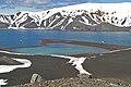
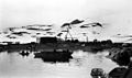
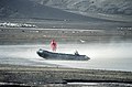
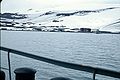
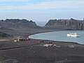
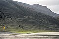
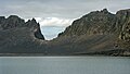
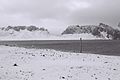
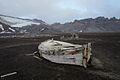
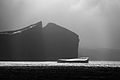
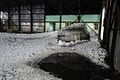
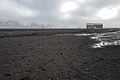
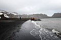
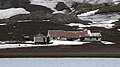
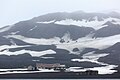
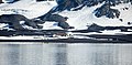
English: Whalers Bay is a small bay entered between Fildes Point and Penfold Point at the east side of Port Foster, Deception Island, in the South Shetland Islands. The bay was so named by the French Antarctic Expedition, 1908-10, under Charcot, because of its use at that time by whalers.
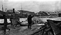
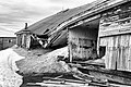
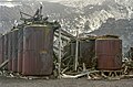
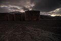
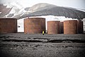
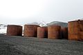
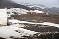
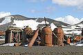
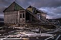
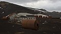
Norsk bokmål: Whalers Bay er en bukt på Deceptionøya i øygruppen Sør-Shetlandsøyene. Bukten var havn for flytende hvalkokerier i første del av 1900-tallet, og fra 1912 til 1931 drev hvalfangstselskapet A/S Hektor fra Tønsberg en landstasjon her.
|
This is a category about Antarctic Protected Area number HSM-71.
|
bay at the east side of Port Foster, Deception Island, in the South Shetland Islands  Remains from the Norwegian whaling station in Whalers Bay | |||||
| Upload media | |||||
| Instance of | |||||
|---|---|---|---|---|---|
| Location | Antarctic Treaty area | ||||
| Operator | |||||
| Heritage designation | |||||
 | |||||
Subcategories
This category has only the following subcategory.
D
Media in category "Whalers Bay (South Shetland Islands)"
The following 200 files are in this category, out of 238 total.
(previous page) (next page)-
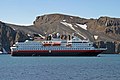 .0 1439 volcanic island Deception Island (Antarctica) - cruise ship of the Hurtigruten.jpg 2,409 × 1,600; 3.03 MB
-
 00 2427 Antarktis - Deception Island (Vulkaninsel) - Walverarbeitungsstation.jpg 2,098 × 1,200; 1.94 MB
-
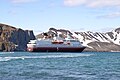 00 2433 Cruise ship of the Hurtigruten - Antarctica.jpg 2,409 × 1,600; 2.82 MB
-
 00 2434 Antarktis - Deception Island - Forschungs- und Walverarbeitungsstation.jpg 2,108 × 1,400; 2.5 MB
-
 00 2440 Antarktis - Deception Island.jpg 2,108 × 1,400; 2.13 MB
-
 00 2445 Antarctica - Deception Island.jpg 2,108 × 1,400; 1.76 MB
-
 1 Deception Island.jpg 2,048 × 1,360; 861 KB
-
 2 Whalers Bay - Deception Island.jpg 2,048 × 1,360; 1.07 MB
-
 7682-whalers-bay-whaling-boat.jpg 600 × 400; 105 KB
-
 A Deception Island.jpg 2,168 × 1,440; 1.58 MB
-
 A-00608 Flenseplan landstasjon.jpg 600 × 351; 151 KB
-
 A-01614b Landstasjon.jpg 600 × 354; 147 KB
-
 Abandoned British research base at Whalers Bay, Deception Island (6024234932).jpg 5,616 × 3,744; 5.24 MB
-
 Abandoned building at Whalers Bay, Deception Island (6023647611).jpg 5,616 × 3,744; 4.08 MB
-
 Abandoned building at Whalers Bay, Deception Island (6023667787).jpg 5,616 × 3,744; 4.73 MB
-
 Abandoned research base at Whalers Bay, Deception Island (6023699089).jpg 5,616 × 3,744; 5.6 MB
-
 Abandoned research base at Whalers Bay, Deception Island (6024248562).jpg 5,616 × 3,744; 6.85 MB
-
 After the Volcano (31818242211).jpg 5,353 × 3,573; 3.37 MB
-
 Antarctic Fur Seal Airplane hanger at Whalers Bay.jpg 600 × 450; 112 KB
-
 Antarctic, Deception Island (js) 42.jpg 5,570 × 3,673; 8.52 MB
-
 Antarctic, Deception Island (js) 43.jpg 5,603 × 3,663; 10.93 MB
-
 Antarctica 2013 Journey to the Crystal Desert (8369525443).jpg 1,280 × 854; 284 KB
-
 Antarctica 2013 Journey to the Crystal Desert (8369533595).jpg 1,280 × 965; 148 KB
-
 Antarctica 2013 Journey to the Crystal Desert (8369534899).jpg 1,280 × 735; 256 KB
-
 Antarctica 2013 Journey to the Crystal Desert (8369535345).jpg 1,280 × 854; 202 KB
-
 Antarctica 2013 Journey to the Crystal Desert (8369539523).jpg 1,280 × 854; 243 KB
-
 Antarctica 2013 Journey to the Crystal Desert (8370591488).jpg 1,280 × 854; 159 KB
-
 Antarctica 2013 Journey to the Crystal Desert (8370596130).jpg 1,279 × 822; 285 KB
-
 Antarctica 2013 Journey to the Crystal Desert (8370596788).jpg 1,280 × 854; 286 KB
-
 Antarctica 2013 Journey to the Crystal Desert (8370597274).jpg 1,280 × 854; 221 KB
-
 Antarctica 2013 Journey to the Crystal Desert (8370597544).jpg 1,280 × 854; 311 KB
-
 Antarctica 2013 Journey to the Crystal Desert (8370598994).jpg 1,280 × 854; 306 KB
-
 Antarctica 2013 Journey to the Crystal Desert (8370599774).jpg 1,280 × 854; 232 KB
-
 Antarctica 2013 Journey to the Crystal Desert (8370599978).jpg 1,280 × 854; 262 KB
-
 Antarctica 2013 Journey to the Crystal Desert (8370602044).jpg 1,280 × 854; 185 KB
-
 Antarctica(js) 43.jpg 5,575 × 3,663; 7.55 MB
-
 Antarctica(js) 44.jpg 5,575 × 3,673; 7.44 MB
-
 Av hvalfangstens historie (1922) (20163989568).jpg 2,730 × 1,216; 1.61 MB
-
 Av hvalfangstens historie (1922) (20325734676).jpg 2,704 × 1,772; 1.79 MB
-
 B Deception Island - Whalers Bay.jpg 2,048 × 1,360; 1.16 MB
-
 Biscoe House (52029402357).jpg 1,024 × 768; 198 KB
-
 Biscoe House (52031911774).jpg 1,024 × 768; 202 KB
-
 Bright spot (28030434008).jpg 4,146 × 2,332; 1.11 MB
-
 Brittle star on the beach at Whalers Bay, Deception Island (6019948411).jpg 5,616 × 3,744; 6.58 MB
-
 Caleta Balleneros.JPG 1,840 × 1,232; 634 KB
-
 Chinstrap Penguins playing in the snow (6019940811).jpg 3,320 × 2,488; 1.72 MB
-
 Chinstrap Penguins tobogganing (6020388906).jpg 1,688 × 1,208; 369 KB
-
 Cookers and Boilers (52029620795).jpg 1,024 × 768; 202 KB
-
 Corroded (50049000408).jpg 4,488 × 2,992; 4.04 MB
-
 Decepcion-Balleneros 2003.jpg 591 × 394; 125 KB
-
 Deception Island (139653141).jpeg 800 × 534; 52 KB
-
 Deception Island (15599975184).jpg 1,024 × 768; 137 KB
-
 Deception Island (195761509).jpeg 2,048 × 1,365; 731 KB
-
 Deception Island (32348916017).jpg 5,894 × 3,315; 2.99 MB
-
 Deception Island (52035777982).jpg 1,024 × 768; 199 KB
-
 DECEPTION ISLAND (8396841084).jpg 1,280 × 754; 202 KB
-
 Deception Island 01(js).jpg 5,594 × 3,673; 8.82 MB
-
 Deception Island 02(js).jpg 5,590 × 3,673; 7.53 MB
-
 Deception Island 03(js).jpg 5,595 × 3,682; 6.35 MB
-
 Deception Island 04(js).jpg 5,594 × 3,673; 6.9 MB
-
 Deception Island 05(js).jpg 5,534 × 3,113; 16.11 MB
-
 Deception Island BW (16) (11125929516).jpg 1,840 × 1,232; 478 KB
-
 Deception Island BW (18) (11126081313).jpg 1,840 × 1,232; 573 KB
-
 Deception Island BW (20) (11126082013).jpg 1,840 × 1,232; 462 KB
-
 Deception Island BW (22) (11125906375).jpg 1,840 × 1,232; 324 KB
-
 Deception Island BW (24) (11125971364).jpg 1,840 × 1,232; 265 KB
-
 Deception Island II.jpg 1,600 × 1,074; 423 KB
-
 Deception Island Telefon Bay (46614972844).jpg 5,236 × 3,491; 8.49 MB
-
 Deception Island Telefon Bay 2 (40373160633).jpg 3,540 × 5,310; 6.3 MB
-
 Deception Island, Antarctica (24309869754).jpg 1,280 × 792; 241 KB
-
 Deception Island, Antarctica (24309877794).jpg 1,280 × 853; 354 KB
-
 Deception Island, Antarctica (24309882384).jpg 1,280 × 853; 420 KB
-
 Deception Island, Antarctica (24309883764).jpg 1,280 × 853; 242 KB
-
 Deception Island, Antarctica (24309884874).jpg 1,280 × 853; 379 KB
-
 Deception Island, Antarctica (24309890304).jpg 1,280 × 853; 318 KB
-
 Deception Island, Antarctica (24309890914).jpg 1,280 × 853; 344 KB
-
 Deception Island, Antarctica (24313613613).jpg 1,280 × 848; 281 KB
-
 Deception Island, Antarctica (24313628833).jpg 1,280 × 853; 206 KB
-
 Deception Island, Antarctica (24313629313).jpg 1,280 × 853; 362 KB
-
 Deception Island, Antarctica (24313629783).jpg 1,280 × 853; 429 KB
-
 Deception Island, Antarctica (24313632783).jpg 1,280 × 853; 381 KB
-
 Deception Island, Antarctica (24313633163).jpg 1,280 × 853; 279 KB
-
 Deception Island, Antarctica (24313633673).jpg 1,280 × 853; 335 KB
-
 Deception Island, Antarctica (24313639643).jpg 1,280 × 853; 153 KB
-
 Deception Island, Antarctica (24313641073).jpg 1,280 × 853; 338 KB
-
 Deception Island, Antarctica (24313642323).jpg 1,280 × 853; 373 KB
-
 Deception Island, Antarctica (24313648603).jpg 1,280 × 853; 179 KB
-
 Deception Island, Antarctica (24572830529).jpg 1,280 × 854; 272 KB
-
 Deception Island, Antarctica (24572833259).jpg 1,280 × 855; 256 KB
-
 Deception Island, Antarctica (24572840279).jpg 1,280 × 836; 212 KB
-
 Deception Island, Antarctica (24572843809).jpg 1,280 × 853; 356 KB
-
 Deception Island, Antarctica (24572844219).jpg 1,280 × 853; 274 KB
-
 Deception Island, Antarctica (24572844619).jpg 1,280 × 853; 372 KB
-
 Deception Island, Antarctica (24572845179).jpg 1,280 × 853; 294 KB
-
 Deception Island, Antarctica (24572849449).jpg 1,280 × 853; 261 KB
-
 Deception Island, Antarctica (24572851309).jpg 1,280 × 853; 146 KB
-
 Deception Island, Antarctica (24572858119).jpg 1,280 × 853; 334 KB
-
 Deception Island, Antarctica (24644980630).jpg 1,280 × 854; 141 KB
-
 Deception Island, Antarctica (24644982810).jpg 1,280 × 837; 207 KB
-
 Deception Island, Antarctica (24644990250).jpg 1,280 × 855; 260 KB
-
 Deception Island, Antarctica (24644990500).jpg 1,280 × 855; 194 KB
-
 Deception Island, Antarctica (24644996810).jpg 1,280 × 842; 174 KB
-
 Deception Island, Antarctica (24645004750).jpg 1,280 × 853; 275 KB
-
 Deception Island, Antarctica (24822506632).jpg 1,280 × 903; 327 KB
-
 Deception Island, Antarctica (24822511792).jpg 1,280 × 855; 317 KB
-
 Deception Island, Antarctica (24822523972).jpg 1,280 × 853; 244 KB
-
 Deception Island, Antarctica (24822526912).jpg 1,280 × 853; 305 KB
-
 Deception Island, Antarctica (24822528372).jpg 1,280 × 853; 245 KB
-
 Deception Island, Antarctica (24822529452).jpg 1,280 × 853; 272 KB
-
 Deception Island, Antarctica (24822542252).jpg 1,280 × 853; 268 KB
-
 Deception Island, Antarctica (24847135691).jpg 1,280 × 854; 278 KB
-
 Deception Island, Antarctica (24847138051).jpg 1,280 × 855; 211 KB
-
 Deception Island, Antarctica (24847138821).jpg 1,280 × 813; 249 KB
-
 Deception Island, Antarctica (24847140711).jpg 1,280 × 855; 264 KB
-
 Deception Island, Antarctica (24847149191).jpg 1,280 × 853; 344 KB
-
 Deception Island, Antarctica (24847150771).jpg 1,280 × 853; 267 KB
-
 Deception Island, Antarctica (24847159811).jpg 1,280 × 892; 309 KB
-
 Deception Island, Antarctica (24847160871).jpg 1,280 × 853; 350 KB
-
 Deception Island, Antarctica (24847163401).jpg 1,280 × 853; 336 KB
-
 Deception Island, Antarctica (24847166531).jpg 1,280 × 853; 347 KB
-
 Deception Island, Antarctica (24847170131).jpg 1,280 × 800; 275 KB
-
 Deception Island, Antarctica (24847170671).jpg 1,280 × 853; 349 KB
-
 Deception Island, Antarctica (24847171961).jpg 1,280 × 853; 224 KB
-
 Deception Island, Antarctica (24914167406).jpg 1,280 × 855; 230 KB
-
 Deception Island, Antarctica (24914170756).jpg 1,280 × 855; 314 KB
-
 Deception Island, Antarctica (24914174216).jpg 1,280 × 855; 244 KB
-
 Deception Island, Antarctica (24914178036).jpg 1,280 × 853; 275 KB
-
 Deception Island, Antarctica (24914181886).jpg 1,280 × 853; 188 KB
-
 Deception Island, Antarctica (24914188166).jpg 1,280 × 853; 370 KB
-
 Deception Island, Antarctica (24914188626).jpg 1,280 × 853; 378 KB
-
 Deception Island, Antarctica (24914191436).jpg 1,280 × 800; 290 KB
-
 Deception Island, Antarctica (24914191876).jpg 1,280 × 853; 323 KB
-
 Deception Island, Antarctica (24914196356).jpg 1,280 × 853; 301 KB
-
 Deception Island, Antarctica (24914196676).jpg 1,280 × 853; 224 KB
-
 Deception Island, Antarctica (24914198056).jpg 1,280 × 853; 203 KB
-
 Deception Island, Antarctica (24940454955).jpg 1,280 × 855; 288 KB
-
 Deception Island, Antarctica (24940469805).jpg 1,280 × 854; 309 KB
-
 Deception Island, Antarctica (24940482235).jpg 1,280 × 853; 300 KB
-
 Deception Island, Antarctica (24940483545).jpg 1,280 × 713; 142 KB
-
 Deception Island, Antarctica (8395620365).jpg 1,280 × 854; 208 KB
-
 Deception Island, Antarctica (8396704074).jpg 1,280 × 854; 199 KB
-
 Deception Island, Antarctica (8396704160).jpg 1,280 × 854; 237 KB
-
 Deception Island, Antarctica (8396704232).jpg 1,280 × 854; 191 KB
-
 Deception Island, Antarctica (8396704324).jpg 1,279 × 709; 184 KB
-
 Deception Island, Antarctica (8396704506).jpg 1,280 × 703; 157 KB
-
 Deception Island-old Whaling Station (17677329293).jpg 3,883 × 2,184; 1.42 MB
-
 Deception Island-old Whaling Station (18110202160).jpg 4,011 × 2,256; 1.55 MB
-
 Deception Island.jpg 2,560 × 1,920; 2.03 MB
-
 Deception Islands - Whalers Bay.jpg 2,168 × 1,440; 1.47 MB
-
 Deception-Base.jpg 1,260 × 825; 110 KB
-
 Deception-Hangar.jpg 1,230 × 825; 85 KB
-
 Deception-Tourists.jpg 1,205 × 806; 518 KB
-
 Desolate (32148506172).jpg 4,950 × 3,300; 2.56 MB
-
 DHC-3 Otter frame in South Shetland Islands.jpg 1,024 × 680; 363 KB
-
 Disused Aircraft Hanger (52032602291).jpg 1,024 × 768; 199 KB
-
 Docked (199561133).jpeg 2,048 × 1,365; 1.26 MB
-
 Docked (32217118662).jpg 5,457 × 3,069; 2.87 MB
-
 Dørnberger - Flensing av blåhval, Whalers Bay, Deception Island.jpg 1,200 × 1,044; 1.02 MB
-
 Estación ballenera.jpg 4,212 × 2,692; 7.99 MB
-
 Excursion No. 12. into the old caldera of Deception Island. (25382968854).jpg 8,194 × 5,463; 29.97 MB
-

-
-
 Hanger where first ever Antarctic flight was launched.jpg 4,608 × 3,072; 6.4 MB
-
 Hunting Lodge (52029774418).jpg 1,024 × 768; 201 KB
-
 In Duigen (32420694195).jpg 5,415 × 3,046; 4.91 MB
-
 Inside a whale oil tank at an abandoned whaling station (6024188668).jpg 5,616 × 3,744; 7.08 MB
-
 Kollaps (31609187593).jpg 5,347 × 3,564; 3.42 MB
-
 Locked Forever (31605875043).jpg 5,023 × 3,357; 4.31 MB
-
 Looking inside an abandoned building at Whalers Bay, Deception Island (6024210456).jpg 5,616 × 3,744; 5.68 MB
-
 Looking inside an abandoned building at Whalers Bay, Deception Island (6024217940).jpg 5,616 × 3,744; 5.59 MB
-
 Looking inside an abandoned building at Whalers Bay, Deception Island (6024226342).jpg 5,616 × 3,744; 6.58 MB
-

-
 Looking inside the abandoned research base at Whalers Bay, Deception Island (6024239070).jpg 5,616 × 3,744; 5.27 MB
-

-
 Looking inside the abandoned research base at Whalers Bay, Deception Island (6024265342).jpg 5,616 × 3,744; 5.36 MB
-
 Lost (200932113).jpeg 2,048 × 1,365; 492 KB
-
 Old Huts for Sealers on Deception Island.jpg 3,649 × 2,444; 8.23 MB
-
 Plants clinging to life on an abandoned building in Antarctica (6023660249).jpg 5,616 × 3,744; 4.95 MB
-
 Pygoscelis papua molting.jpg 1,200 × 782; 117 KB
-
 Relics of an old whaling station at Whalers Bay, Deception Island (6023703911).jpg 5,616 × 3,744; 6.08 MB
-
 Relics of an old whaling station at Whalers Bay, Deception Island (6023717969).jpg 5,616 × 3,744; 4.06 MB
-
 Relics of an old whaling station at Whalers Bay, Deception Island (6024183244).jpg 5,616 × 3,744; 4.01 MB
-
 Remains (18778684263).jpg 4,225 × 2,377; 1.98 MB
-
 Remnants Of The Past (225728279).jpeg 2,048 × 1,407; 1.02 MB
-
 Ruiner i Whalers Bay.jpg 1,600 × 1,200; 291 KB
-
 Ruins in Whalers Bay, Deception Island.jpg 1,280 × 854; 255 KB
-
 Sealed (32367339205).jpg 5,070 × 3,380; 4.26 MB
-
 SeMo-287 (49434901148).jpg 6,720 × 4,480; 2.55 MB
-
 South Shetland-2016-Deception Island–Whalers Bay.jpg 6,438 × 4,292; 9.48 MB
-
 South Shetland-2016-Deception Island–Whaling station 01.jpg 6,508 × 3,210; 13.38 MB
-
 South Shetland-2016-Deception Island–Whaling station 02.jpg 6,750 × 4,500; 15.88 MB
-
 Stove (17677328743).jpg 4,204 × 2,364; 2.46 MB
-
 The World Factbook - Antarctica - Flickr - The Central Intelligence Agency (9).jpg 1,500 × 1,000; 210 KB
-
 VU0K2106 (39985941).jpg 800 × 446; 115 KB
-
 VU0K2114 (39985953).jpg 800 × 480; 99 KB
-
 VU0K2189 1 (39985985).jpg 800 × 487; 107 KB
-
 VU0K2214 (39986014).jpg 800 × 475; 73 KB
-
 Water vessel (18640754854).jpg 4,122 × 2,319; 2.48 MB
-
 Whale Oil Containers (21008952979).jpg 4,308 × 2,423; 2.02 MB
-
 Whale Oil Storage (52027862771).jpg 1,024 × 768; 199 KB
_-_cruise_ship_of_the_Hurtigruten.jpg)
_-_Walverarbeitungsstation.jpg)


.jpg)
.jpg)
.jpg)
.jpg)
.jpg)
.jpg)

_42.jpg)
_43.jpg)
.jpg)
.jpg)
.jpg)
.jpg)
.jpg)
.jpg)
.jpg)
.jpg)
.jpg)
.jpg)
.jpg)
.jpg)
.jpg)
.jpg)
_43.jpg)
_44.jpg)
_(20163989568).jpg)
_(20325734676).jpg)

.jpg)
.jpg)
.jpg)
.jpg)

.jpg)
.jpg)
.jpg)
.jpg)

.jpeg)
.jpg)
.jpeg)
.jpg)
.jpg)
.jpg)
.jpg)
.jpg)
.jpg)
.jpg)
.jpg)
_(11125929516).jpg)
_(11126081313).jpg)
_(11126082013).jpg)
_(11125906375).jpg)
_(11125971364).jpg)

.jpg)
.jpg)
.jpg)
.jpg)
.jpg)
.jpg)
.jpg)
.jpg)
.jpg)
.jpg)
.jpg)
.jpg)
.jpg)
.jpg)
.jpg)
.jpg)
.jpg)
.jpg)
.jpg)
.jpg)
.jpg)
.jpg)
.jpg)
.jpg)
.jpg)
.jpg)
.jpg)
.jpg)
.jpg)
.jpg)
.jpg)
.jpg)
.jpg)
.jpg)
.jpg)
.jpg)
.jpg)
.jpg)
.jpg)
.jpg)
.jpg)
.jpg)
.jpg)
.jpg)
.jpg)
.jpg)
.jpg)
.jpg)
.jpg)
.jpg)
.jpg)
.jpg)
.jpg)
.jpg)
.jpg)
.jpg)
.jpg)
.jpg)
.jpg)
.jpg)
.jpg)
.jpg)
.jpg)
.jpg)
.jpg)
.jpg)
.jpg)
.jpg)
.jpg)
.jpg)
.jpg)
.jpg)
.jpg)
.jpg)
.jpg)
.jpg)
.jpg)
.jpg)
.jpg)
.jpg)


.jpg)

.jpg)
.jpeg)
.jpg)


.jpg)
.jpg)
.jpg)

.jpg)
.jpg)
.jpg)
.jpg)
.jpg)
.jpg)
.jpg)
.jpg)
.jpg)
.jpg)
.jpg)
.jpg)
.jpeg)

.jpg)

.jpg)
.jpg)
.jpg)
.jpg)
.jpeg)


.jpg)
.jpg)


.jpg)
.jpg)
.jpg)
.jpg)
.jpg)
.jpg)
.jpg)
.jpg)
.jpg)
&filefrom=Whale+Oil+Storage+Tanks+%2816039019129%29.jpg#mw-category-media)